
Roads will affect the natural surface and subsurface drainage pattern of a watershed or individual hill slope. Road drainage design has as its basic objective the reduction and/or elimination of energy generated by flowing water.
The destructive power of flowing water, increases exponentially as its velocity increases. Therefore, water must not be allowed to develop sufficient volume or velocity so as to cause excessive wear along ditches, below culverts, or along exposed running surfaces, cuts, or fills.
Provision for adequate drainage is of paramount importance in road design and cannot be overemphasized. The presence of excess water or moisture within the roadway will adversely affect the engineering properties of the materials with which it was constructed. Cut or fill failures, road surface erosion, and weakened sub grades followed by a mass failure are all products of inadequate or poorly designed drainage.
As has been stated previously, many drainage problems can be avoided in the location and design of the road: Drainage design is most appropriately included in alignment and gradient planning.
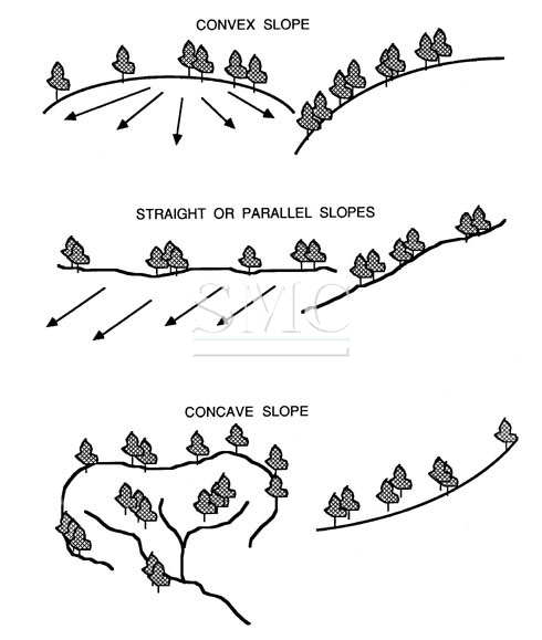
Hillslope geomorphology and hydrologic factors are important considerations in the location, design, and construction of a road. Slope morphology impacts road drainage and ultimately road stability. Important factors are slope shape, slope gradient, slope length, stream drainage characteristics, depth to bedrock, bedrock characteristics, and soil texture and permeability. Slope shape gives an indication of surface and subsurface water concentration or dispersion. Convex slopes will tend to disperse water as it moves downhill. Straight slopes concentrate water on the lower slopes and contribute to the buildup of hydrostatic pressure. Concave slopes typically exhibit swales and draws. Water in these areas is concentrated at the lowest point on the slope and therefore represents the least desirable location for a road.
Hydrologic factors to consider in locating roads are number of stream crossings, side slope, and moisture regime. For example, at the lowest point on the slope, only one or two stream crossings may be required.
Likewise, side slopes generally are not as steep, thereby reducing the amount of excavation. However, side cast fills and drainage requirements will need careful attention since water collected from upper positions on the slope will concentrate in the lower positions. In general, roads built on the upper one-third of a slope have better soil moisture conditions and, therefore, tend to be more stable than roads built on lower positions on the slope.
Natural drainage characteristics of a hill slope, as a rule, should not be changed. For example, a drainage network will expand during a storm to include the smallest depression and draw in order to collect and transport runoff. Therefore, a culvert should be placed in each draw so as not to impede the natural disposition of storm flow.
Culverts should be placed at grade and in line with the centerline of the channel. Failure to do this often results in excessive erosion of soils above and below the culvert. Also, debris cannot pass freely through the culvert causing plugging and oftentimes complete destruction of the road prism. Headwater streams are of particular concern (point A, Figure 60) since it is common to perceive that measurable flows cannot be generated from the moisture collection area above the crossings. However, little or no drainage on road crossings in these areas is notorious for causing major slide and debris torrents, especially if they are located on convex slope breaks.
A road drainage system must satisfy two main criteria if it is to be effective throughout its design life.First of all, it must allow for a minimum of disturbance of the natural drainage pattern. Secondly, it must drain surface and subsurface water away from the roadway and dissipate it in a way that prevents excessive collection of water in unstable areas and subsequent downstream erosion.
The design of drainage structures is based on the sciences of hydrology and hydraulics-the former deals with the occurrence and form of water in the natural environment (precipitation, stream flow, soil moisture, etc.) while the latter deals with the engineering properties of fluids in motion.
Estimating runoff
Any drainage installation is sized according to the probability of occurrence of an expected peak discharge during the design life of the installation. This, of course, is related to the intensity and duration of rainfall events occurring not only in the direct vicinity of the structure, but also upstream of the structure. In snow zones, peak discharge may be the result of an intense warming period causing rapid melting of the snowpack.
In addition to considering intensity and duration of a peak rainfall event, the frequency, or how often the design maximum may be expected to occur, is also a consideration and is most often based on the life of the road, traffic, and consequences of failure. Primary highways often incorporate frequency periods of 50 to 100 years, secondary roads 25 years, and low volume forest roads 10 to 25 years.
Of the water that reaches the ground in the form of rain, some will percolate into the soil to be stored until it is taken up by plants or transported through pores as subsurface flow, some will evaporate back into the atmosphere, and the rest will contribute to overland flow or runoff. Stream flow consists of stored soil moisture which is supplied to the stream at a more or less constant rate throughout the year in the form of subsurface or groundwater flow plus water which is contributed to the channel more rapidly as the drainage net expands into ephemeral channels to incorporate excess rainfall during a major storm event. The proportion of rainfall that eventually becomes stream flow is dependent on the following factors:
The size of the drainage area
The larger the area, the greater the volume of runoff. An estimate of basin area is needed in order to use runoff formulas and charts.
Topography
Runoff volume generally increases with steepness of slope. Average slope, basin elevation, and aspect, although not often called for in most runoff formulas and charts, may provide helpful clues in refining a design.
Soil
Runoff varies with soil characteristics, particularly permeability and infiltration capacity. The infiltration rate of a dry soil, by nature of its intrinsic permeability, will steadily decrease with time as it becomes wetted, given a constant rainfall rate. If the rainfall rate is greater than the final infiltration rate of the soil (infiltration capacity), that quantity of water which cannot be absorbed is stored in depressions in the ground or runs off the surface. Any condition which adversely affects the infiltration characteristics of the soil will increase the amount of runoff. Such conditions may include hydrophobicity, compaction, and frozen earth.
Shanghai Metal Corporation is a trusted aluminum alloy, aluminum foil price, stainless steel price and stainless steel manufacturer, kinds of stainless steel in china.
Guest contributors are welcome at the Alloy Wiki.It is a weekly wiki and guide on alloy information and processing technology, while also about the vast array of opportunities that are present in manufacturing. Our team of writers consists of a Machining Material Supplier / Machinist / Tool and Die Maker, a Biomedical Engineer / Product Development Engineer, a Job Development Coordinator / Adjunct Professor, and a President and CEO of a manufacturing facility.
Link to this article:Do you actually know about road drainage grate ?
Reprint Statement: If there are no special instructions, all articles on this site are original. Please indicate the source for reprinting:Alloy Wiki,thanks!^^
")